List of capital improvement projects (CIP).
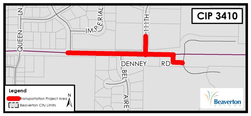
CIP 3410 - Shared Use Path along Denney Rd (King Blvd-Fanno Creek Trailhead)
Status: Completed project
Project Category: Transportation
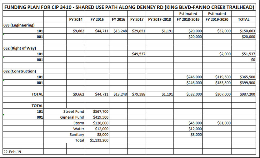
Project Estimated Cost: $1,133,200
Project Description
This project will provide a shared use path on the north side of Denney Rd from the Fanno Creek trailhead to King Blvd that will connect to bike boulevards on King Blvd, Alger Ave, and 11th St and to existing bike lanes and shared bikeways on 5th St and Lombard Ave to the Beaverton Transit Center. The striping for the bike boulevards will be completed by City Forces after the shared use path project is complete (see CIP 3410A). The project also includes storm drainage improvements on 111th Ave and an enhancement of the storm drainage way in the vicinity of the parking lot at the Fanno Creek Trailhead.
Comments
Carryover from FY 18-19 to FY19-20: $491,927
Project Manager(s)
unassigned
mailboxengineering@beavertonoregon.gov
Project Schedule
FY11-12: Project originally included in CIP 3407 as part of the grant approved under the ODOT Flexible Funds Program on 3-22-12.
FY12-13: Project still included in CIP 3407 and in ODOT IGA 28470 that was executed on 7-20-12. FY13-14: Project removed from CIP 3407 and from the ODOT grant scope of work. OTAK completed survey. City staff began design.
FY14-15: 30% design completed 1-30-15. 60% design completed 6-30-15; however, ODOT had multiple comments that required substantial changes to the design.
FY15-16: Completed 90% design incorporating ODOT comments. FY16-17: ROW acquired from 3 properties. Final design completed 10-17-16.
FY17-18: No work.
FY18-19: Final design updated on 11-28-18 to include storm drainage work on 111th Ave. Land use preapp held on 12-12-18. 2-1-19 & 2-15-19: Met with ODOT to coordinate extending the path from the Fanno Creek Trailhead east 170 feet to the west side of the Denney Frontage Rd. ODOT has offered to pay $50,000 for these improvements. 2-18-19: Revised design to delete LIDA and add enhancement of an existing drainage way in the vicinity of the parking lot at the Fanno Creek Trailhead. 2-21-19: Made project presentation to Vose NAC. 2-22-19: Submitted CWS Sensitive Area Certification form. 3-4-19: Received draft ODOT IGA for extending the trail east from the Fanno Creek Trailhead to the west side of the Denney Frontage Road. 3-5-19: CWS states that application requires a Natural Resource Assessment. 4-10-19: Submitted Natural Resource Assessment and CWS Sensitive Area Certification Form to CWS. 4-22-19: Signed IGA 33318 with ODOT for section of path between the Fanno Creek Trailhead and the Denney Frontage Rd. 4-23-19: Received CWS SPL #19-000604. 5-9-19: Received land use approval. 5-21-19: Council approved staff request not to underground overhead utilities. 6-21-19: Advertised project. 6-27-19: Held pre-bid meeting.
FY19-20: 8-1-19: Bids opened. Pacific Excavation was apparent low bidder. 8-13-19: Council awarded contract to Pacific Excavation. 9-6-19: PGE relocation plan to be completed. 9-24-19: Precon meeting held. 12-18-19: NTP issued. 1-6-20: Began work. Jan 2020: 27% complete. Work completed: Fence removal, block wall removal, excavation, and block wall construction east of 111th Ave. Feb 2020: 58% complete. Work completed: Lock+Load wall, water service adjustment, installation of street light and interconnect conduit, pole foundations, and junction boxes. 2-18-20: PGE Line Extension Agreement finalized. 4-30-20: Complete construction.
Project Justification
The intent of the project is to positively impact modal connectivity, the environment, mobility and access, livability, energy use, and the overall operation of the transportation system by improving 1000 feet of existing asphalt sidewalk to a 10-foot wide shared use path. Amendment 1 to COB/ODOTIGA 28470 was approved 2-15-15 and requires that City complete CIP 3410 as a condition of approval of the IGA.
This project is one segment of the planned Beaverton Creek Trail, which extends from Fanno Creek to the THPRD Boundary near 185th Ave and supports Comprehensive Plan Goals 6.2.1 (policy g), 6.2.2 (policies a-e), 6.2.3 (policies d and e), 6.2.5 (policy a), and 6.2.7 (policy a); and TSP Action Plan (Table 6-1) Project #71.
This project responds to Community Vision Action Plan #54 upgrade trails to include lighting & better connectivity and #88 connect parks and green spaces with trails/bike routes.
Project Image(s)